
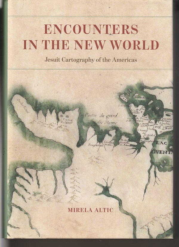
A strikingly drawn and boldly colored map, attributed to the Jesuit priest and explorer Jean de Brebeuf, is the image used on the cover of Mirela Altic’s Encounters in the New World: Jesuit Cartography of the Americas, published by the University of Chicago Press.
The cover image is a portion — about the top half — of a map that Brebeuf made between 1639 and 1648 of the lands then occupied by the Huron tribes, an area in present-day Ontario encompassing Lake Simcoe and Lake Huron’s Georgian Bay.
Altic, a professor of the history of cartography at the University of Zagreb (Croatia) and president of the Society for the History of Discoveries, notes that Brebeuf’s map isn’t as accurate as some others drawn by the Jesuits in New France (today’s Canada) in the seventeenth century.
Nevertheless, it is important as one of the earliest preserved Jesuit maps from the mission fields of the Americas and one that shows the results of the exploration that members of the Society of Jesus, the formal name of the Jesuits, conducted in the area.
Brebeuf’s is also a rare map of that era, giving, as it does, two names of places, one designated by the indigenous peoples and the other by the French newcomers. This is a key source of information for present-day historians trying to piece together the history of the First Nations, as those native peoples are now called in Canada. Usually maps only gave the native name of a place if the French hadn’t renamed it.
Another distinction
Brebeuf’s map is distinctive for yet another reason:
It is a map of the area where, in 1649, Brebeuf was among three Jesuit priests who were captured by Iroquois warriors at war with the Hurons, tortured brutally and killed. In 1930, he was canonized by Pope Pius XI and proclaimed a patron saint of Canada. He is memorialized in the Chicago area with St. John Brebeuf Roman Catholic parish in Niles.
Although it is likely to surprise many people interested in world and American history, Jesuit missionaries were among the most important mapmakers in the New World. Indeed, not only in the Americas, but earlier in China, Japan and India.
Encounters in the New World is the first book to bring together a vast amount of history and images to recount the cartographic work of the Society of Jesus in the Spanish, Portuguese and French possessions in the Americas. In a monumental effort of historical research, Altic has brought together in her book more than a hundred Jesuit maps, held in some forty institutions around the world.
A book for cartographers
 This is a book for map-makers and map-lovers, and, for her professional readers, Altic goes into great detail about the equipment used by Jesuit missionaries to determine or approximate longitude and latitude, about the map-markings employed and about the degree of accuracy exhibited. She also delves deeply into the ways manuscript maps would be turned into printed versions, sometimes improved with additional data, sometimes diminished by the inclusion of erroneous material. And also how home government would use and sometime keep secret Jesuit maps.
For cartographers, this is a four-star book. For the general reader, not so much, especially at a cost of $75.
Nonetheless, it has many riches for anyone interested in the exploration of the area that came to be Chicago and the center of the United States along the Mississippi River.
Not just map-makers
Jesuits weren’t just map-makers. They were missionaries bringing Christianity to indigenous peoples. They were asserting that the religious traditions of the people they found needed to be replaced by a belief in Jesus Christ. In doing so, they courted danger. And many, such as Jean de Brebeuf, were martyred for their faith.
Encounters in the New World opens with Altic’s 73-page overview of the Jesuit map-making efforts in which she discusses the religious order’s strength as a school-founding order and as an institution that trained its missionaries in the natural sciences. She writes:
“Thanks to their well-organized colleges and seminaries, the Jesuits were among the best-educated people of their time, and many of them became tutors, confessors, and counselors to countless prominent figures and rulers.”
Many Jesuits, however, weren’t content to stay in academic settings as teachers or to work their influence as advisors to the power brokers of their day. They wanted to go into the mission field to bring Christianity to the indigenous peoples in foreign lands, particularly in the newly discovered continents of North and South America.
Unlike most explorers of this era, the Jesuits weren’t going out into the unknown for riches or trade or power. For them, the native people weren’t obstacles to profit — they were the goal of the traveling. They were people to whom the missionaries could preach by word and example the lessons of Jesus Christ.
Worked with rather than against
So, Jesuit exploration was a search for new people to hear their gospel message. They worked with rather than against the natives, and their maps show this. Altic writes:
“The Jesuits were the most important links, bringing the two cultures together, and they successfully enabled transatlantic cultural exchanges between the Old and New Worlds.”
The middle 200 pages of Altic’s book examine Jesuit map-making in the lands claimed by Spain in the Americas as well as in Brazil, claimed as a Portuguese possession. The final 35 pages look at the Society of Jesus missionaries in New France — an area that includes what is now southern Canada and much of the Upper Midwest as well as the lands along the Mississippi River to Louisiana.
The Jesuits in New France
This last section is the one most likely to be of interest to an American general reader. It examines the work of Jesuit missionary-mapmakers in the Great Lakes region, including Jacques Marquette, and it reports the long journey that Marquette took with Louis Joliett to find, as the first Europeans, the Mississippi River and follow it down to present-day Arkansas.
On the way back, the two explorers and their party passed through the place that today is Chicago.
Although not mentioned by Altic, Joliett’s report on the trip identified Chicago as a key place for future development since, as he said, a channel through Mud Lake would link Lake Michigan and the Mississippi. It was a plan to build that channel — the Illinois & Michigan Canal — that spurs development of Chicago in the early 1800s.
Altic does, however, present a full-page color copy of the map that Maquette made of the journey, a map lost for nearly 200 years. Two years after completing the map, Marquette died of dysentery, worn out by his missionary efforts. He is remembered as an important explorer of the lands that became the United States.
Remembering Jesuit martyrs
Martyred Jesuits were remembered by their fellow missionaries in some maps made during these years by marks indicating the spots where they were killed.
Altic also discusses another way the martyrs were memorialized when she writes about a map of New France created by Francesco Giuseppe Bressani, an Italian Jesuit who had been tortured and mutilated by the Mohawks in the 1640s.
In this map, Bressani has in the upper left corner a native family kneeling under a celestial cross, examples of those who had accepted Christianity, but, in the lower right corner, there is a large illustration, occupying about a quarter of the map, depicting the martyrdom of Jean de Brebeuf and Gabriel Lalemant. And to the left is a small scene of ten other Jesuit martyrs.

.
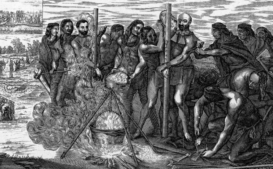
This map brings the martyrdom of the Jesuits to the fore, but also their Christianization efforts. As Altic writes:
“Barbarism, it says, is not inherent to Indians — it is the absence of revelation that causes their cruel behavior.”
And she notes that Bressani makes clear that neither he nor his order have bitterness or condemnation by “adding other illustrations to the map in which the native people are shown engaged in their daily activities — dancing, hunting, canoeing, attending to their children, and preparing food.”
That represents quite a nuanced recognition of the indigenous people as human beings, and, as such, it is quite different from that expressed in much else that was written in that era by non-Jesuit explorers and mapmakers.
Patrick T. Reardon
4.5.24
This review originally appeared at Third Coast Review on 3.14.24.
Written by : Patrick T. Reardon

For more than three decades Patrick T. Reardon was an urban affairs writer, a feature writer, a columnist, and an editor for the Chicago Tribune. In 2000 he was one of a team of 50 staff members who won a Pulitzer Prize for explanatory reporting. Now a freelance writer and poet, he has contributed chapters to several books and is the author of Faith Stripped to Its Essence. His website is https://patricktreardon.com/.

Thanks for this review, Pat.